
Supply in Kazakhstan
KEG TRK supplies equipment diagnostics solutions (Skyline Software) across Kazakhstan: Almaty, Astana, Karaganda, Ust-Kamenogorsk, Aktobe and other regions. Official warranty, monitoring system design, installation, commissioning and personnel training.
Key features
Applications and resources
Industry solutions, landing pages and articles on SkylineGlobe Hosting — managed cloud geodata hosting on AWS
Typical tasks
- A fast start for publishing geodata without buying and configuring a server
- Browser-based access to a digital twin for contractors and remote teams
- Replacing an on-premise SkylineGlobe Server deployment with a managed cloud service
- Variable-load projects where paying for cloud beats paying for idle hardware
Overview
SkylineGlobe Hosting is a SkylineCloud service that takes deployment and administration of SkylineGlobe Server off your plate — the service that stores, catalogs, and streams a company's 2D/3D geodata. Instead of buying and configuring server hardware, the customer gets ready-made infrastructure on AWS.
What's included
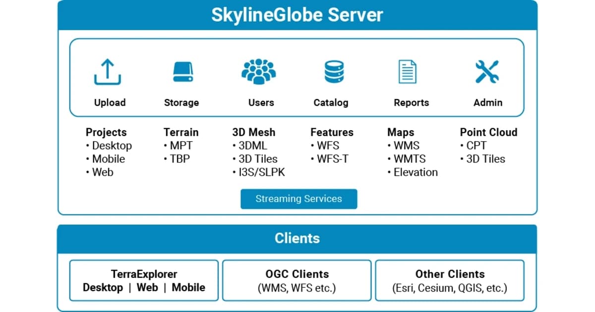
Upload, storage, conversion, and streaming for nearly unlimited volumes of geodata — terrain, orthophoto, 3D mesh, point clouds, and vector layers — on private virtual geoservers with their own authentication. Built-in SkylineGlobe tools handle catalog search and project management.
Compatible without reworking your process
Data hosted in SkylineGlobe Hosting is available to TerraExplorer clients — Desktop, Fusion, and Mobile — exactly as it would be with an on-premise server. Open protocols (WMS, WMTS, WFS) also provide access from third-party systems — ArcGIS, Cesium, QGIS — without duplicating or converting data separately for each platform.
When it beats running your own server
For companies without dedicated IT infrastructure for geodata, or with variable, unpredictable load, cloud hosting removes the need to buy hardware sized for peak load and keep it idle the rest of the time. This matters most for projects involving contractors and remote teams who need browser-based access to a site's digital twin without installing specialized software.
Technical specifications
| Manufacturer | Skyline Software |
| Platform | SkylineCloud (built on AWS) |
| Built on | SkylineGlobe Server |
| Deployment | Fully managed cloud hosting |
| Security | Private geoservers, authentication, access permissions |
Applications
Manufacturer
Skyline Software
A managed SkylineCloud service built on SkylineGlobe Server: upload, store, convert, and stream 2D/3D geodata without deploying or administering a server of your own
Key specifications
- Manufacturer
- Skyline Software
- Platform
- SkylineCloud (built on AWS)
- Built on
- SkylineGlobe Server
- Deployment
- Fully managed cloud hosting
- Security
- Private geoservers, authentication, access permissions
Official supplier in Kazakhstan
Related products
SkylineGlobe Server — 3D geodata publishing and streaming server
Private cloud server for storing, managing and streaming 2D/3D geospatial data — compatible with TerraExplorer, Esri, Cesium and QGIS
- Skyline Software
- Geodata publishing and streaming server
PhotoMesh Production — turnkey cloud photogrammetry processing
A SkylineCloud service: drone and aerial imagery processed in PhotoMesh without buying software or building your own compute — fully automated on AWS, or handled by Skyline's photogrammetry experts
- Skyline Software
- SkylineCloud (built on AWS)
TerraExplorer Fusion — web-based 3D geodata viewer, no install
The web edition of TerraExplorer: view, measure and analyze a high-resolution 3D digital twin right in the browser — no install, on Windows, Mac, Linux
- Skyline Software
- TerraExplorer Fusion (Viewer / Plus)
Need advice?
Our specialists will help you choose the optimal SkylineGlobe Hosting — managed cloud geodata hosting on AWS configuration for your equipment.